


Name Countries Of Asia: Region 6
Subject: Social studies
Grade: Sixth grade
Topic: Asia: Geography
Please LOG IN to download the presentation. Access is available to registered users only.
View More Content


Exploring Asia: The Largest Continent
– Asia: Earth’s largest continent
Asia covers 30% of Earth’s land area.
– Cultural and landscape diversity
Home to various climates, from icy Siberia to tropical Indonesia.
– Asia’s global significance
A major player in global economics, politics, and culture.
– Engage with Asia’s uniqueness
|
Begin the lesson by highlighting Asia’s size and the fact that it’s the largest continent on Earth, making up 30% of the planet’s land. Emphasize the incredible diversity found within Asia, including a wide range of cultures, languages, religions, and landscapes, from the vast tundra of Siberia to the dense rainforests of Southeast Asia. Discuss Asia’s significant role in the world in terms of economy, politics, and culture, and how this impacts global dynamics. Encourage students to think about the uniqueness of each region within Asia, and how this diversity contributes to the continent’s overall identity. This introduction sets the stage for a deeper dive into the specific countries and regions, including ‘region 6’ which will be covered in subsequent slides.
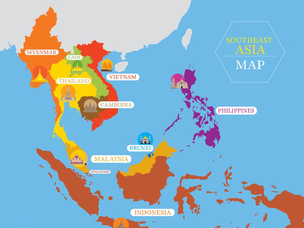
Exploring Asia: Region 6
– Locate Region 6 on the map
– Find Region 6 in the southern part of Asia
– Countries within Region 6
– Examples: India, Pakistan, Bangladesh
– Main geographical features
– Features like the Himalayas, Ganges River
– Cultural significance
– Rich history, diverse cultures across countries
|
This slide aims to introduce students to Region 6 of Asia, which includes some of the most populous and culturally rich countries in the world. Start by showing where Region 6 is located, perhaps using a classroom map or an interactive globe. List the countries that are part of this region, focusing on India, Pakistan, and Bangladesh as examples. Discuss the main geographical features, such as the Himalayan mountain range and the Ganges River, which are significant not only for their physical presence but also for their cultural and spiritual importance to the people living in this region. Highlight the diversity and the historical significance of the region to give students a broader understanding of its global impact.
Exploring Asia: Region 6 Country Profiles
– Examine countries in Asia’s Region 6
– Capitals, languages, and populations
– For example, Japan: Capital – Tokyo, Language – Japanese, Population – approx. 126 million
– Share unique country facts
– Japan is home to the world’s busiest pedestrian crossing, Shibuya Crossing
– Engage with cultural diversity
– Understanding diversity enhances global awareness and appreciation
|
This slide aims to provide students with a deeper understanding of the countries within Asia’s Region 6. Students will research and discuss key facts about each country, including the capital city, official language(s), and population size. Additionally, they will find and share an interesting or unique fact about each country to spark curiosity and engagement. This activity will help students appreciate the cultural diversity within Asia and understand the significance of each country’s unique identity. Encourage students to look beyond basic facts and explore elements such as history, culture, and geography that shape the identity of these nations.
Exploring Region 6 of Asia: Physical Geography
– Major rivers, mountains, and deserts
– Explore the Yangtze River, Himalayas, and Gobi Desert
– Climate impact on life
– How do monsoons and arid conditions affect agriculture and settlements?
– Natural resources in Region 6
– Discover coal, oil, and precious metals available in the region
|
This slide aims to introduce students to the physical geography of Asia’s Region 6, which includes diverse landscapes such as the Yangtze River, Himalayan Mountains, and the Gobi Desert. Discuss how these geographical features influence the climate of the region, including monsoon rains and arid desert conditions, and how this, in turn, affects the way people live, work, and cultivate the land. Highlight the abundance of natural resources like coal in China, oil reserves in Central Asia, and precious metals across the region. Encourage students to think about how geography can shape the economy and culture of a place. Provide examples and ask students to consider how living near a major river or mountain range might differ from living in a desert area.
Cultural Highlights of Asia: Region 6
– Explore diverse cultures in Region 6
– Region 6 includes countries with rich and varied traditions.
– Traditional clothing, festivals, and food
– Kimono in Japan, Diwali in India, Sushi and Kimchi as traditional foods.
– Respect for cultural differences
– Embracing diversity promotes harmony and understanding.
– Significance of cultural diversity
|
This slide aims to introduce students to the rich cultural tapestry of Asia’s Region 6. Highlight the unique traditional clothing such as the Kimono in Japan, the vibrant festivals like Diwali in India, and the delicious array of foods, including sushi from Japan and kimchi from Korea. Emphasize the importance of respecting and valuing cultural differences, which is key to global citizenship. Discuss the significance of cultural diversity and how it contributes to the richness of the human experience. Encourage students to share any personal experiences or knowledge related to the cultures of Region 6.
Economic Activities in Asia: Region 6
– Main economic activities identified
– Agriculture, manufacturing, services
– Geography’s impact on economy
– Mountains, rivers, and climate shape economy
– Trade within Region 6
– Exchanging goods with neighbors
– Global trade connections
– Exporting goods worldwide boosts economy
|
This slide aims to explore the various economic activities prevalent in Asia’s Region 6. Students should understand that the main economic activities can include agriculture, where the climate and fertile land play a significant role, manufacturing, which may be influenced by the availability of resources and labor, and services that are shaped by the population’s needs and education. Geography, including physical features like mountains and rivers, as well as climate, directly affects these economic activities. Additionally, trade is a crucial aspect, both within the region, where countries may exchange goods that are abundant or scarce, and on a global scale, where countries can expand their markets. Encourage students to think about how these factors interconnect and influence the livelihoods of people in the region.
Class Activity: Mapping Asia’s Region 6
– Receive a blank map of Asia
– Label Region 6 countries and capitals
– Color geographical features and create a key
– Include features like the Mekong River or the Himalayas
– Present map and share an interesting fact
– Maybe share about a country’s culture or history
|
This activity is designed to help students visually and interactively learn about the geography of Asia, specifically Region 6. Provide each student with a blank map and instruct them to label the countries within Region 6, along with their capitals. They should also color in geographical features such as rivers and mountains and create a corresponding key. Encourage creativity and accuracy. Once completed, each student will present their map to the class and share one interesting fact they learned during the activity. This could be related to the geography, culture, or history of a country they found particularly interesting. For the teacher: Prepare a list of countries and capitals in Region 6, have colored pencils or markers available, and consider having a few examples of interesting facts to help students who might have difficulty finding one on their own.
