Identify And Select Countries Of Europe: Region 3
Subject: Social studies
Grade: Sixth grade
Topic: Europe: Geography
Please LOG IN to download the presentation. Access is available to registered users only.
View More Content
Exploring Europe: Region 3
– Europe’s diverse geography
– A continent with varied landscapes, climates, and cultures.
– What are ‘regions’?
– ‘Regions’ divide Europe into manageable areas for study.
– Focus on Region 3 countries
– We’ll identify key countries in Europe’s third region.
– Recognizing borders and features
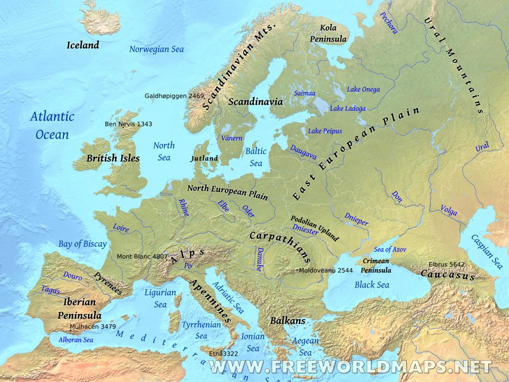
– Use maps to locate countries and understand their geography.
|
This slide introduces students to the geography of Europe, emphasizing the diversity of the continent. It explains the concept of ‘regions’ as a way to simplify the study of Europe’s complex geography. Today’s lesson will focus on the countries that make up Europe’s Region 3, which could include a specific set of countries depending on the classification system used. Students will learn to recognize the borders, physical features, and cultural characteristics that define this region. Encourage students to think about how geography can influence culture and history. Provide maps for students to visually locate and connect with the countries discussed.
Understanding Regions in Geography
– What defines a region?
– A region is an area defined by certain criteria like language, climate, or history.
– Characteristics of regions
– Common features: landforms, culture, economic activities, or political agreements.
– Regions differ globally
– For example, the Sahara is defined by its desert climate, while Latin America shares cultural and linguistic traits.
– Europe’s diverse regions
– Region 3 in Europe may be defined by specific languages, history, and geographical features.
|
This slide introduces the concept of a region, which is a crucial part of understanding geography. A region is an area that is defined by certain distinctive characteristics, which can be physical, cultural, economic, or political. It’s important to discuss with students how these characteristics come together to define a region. Provide examples of other regions around the world to illustrate the concept. Then, relate this understanding to Europe, which is divided into various regions, each with its own unique identity. Encourage students to think about what might define Region 3 in Europe, such as common languages, a shared history, or similar climate and landforms.
Exploring Europe: Focus on Region 3
– Locate Region 3 on the map
– Use a map of Europe to point out Region 3’s location
– Enumerate countries in Region 3
– List countries such as Italy, Switzerland, Austria
– Discover unique country facts
– Share facts like Italy’s famous for pizza, Switzerland for watches
– Discuss cultural significance
– Understand how culture shapes each country’s identity
|
This slide aims to familiarize students with Region 3 of Europe, which includes countries like Italy, Switzerland, and Austria. Start by showing where Region 3 is located on a European map. Then, list the countries that are part of this region. For each country, share unique facts that highlight their cultural and historical significance. For example, Italy is renowned for its contribution to art and cuisine, Switzerland for its precision in watch-making and banking, and Austria for its classical music heritage. Encourage students to think about how the geography of these countries has influenced their culture and history. This will help students appreciate the diversity within Europe and understand the importance of geography in shaping the world.
Physical Geography of Europe: Region 3
– Mountains and rivers in Region 3
– Explore the Alps and Danube River
– Geography’s impact on life and culture
– How mountains/rivers shape traditions, jobs
– Climate characteristics of Region 3
– Discuss variations from Mediterranean to continental climates
– Exploring Region 3’s diverse landscapes
|
This slide aims to explore the physical geography of Europe’s Region 3, which includes features like the Alps and the Danube River. Highlight how these physical features influence the daily life, culture, and occupations of the people living in this region. For example, mountainous areas may lead to skiing culture or alpine farming practices, while rivers can be central to trade and transportation. Discuss the climate of Region 3, which can range from the warm Mediterranean to cooler continental climates, affecting agriculture and lifestyle. Encourage students to think about how living in such a region would differ from their own experiences and to consider the diversity of landscapes within a single geographic region.
Cultural Highlights of Europe: Region 3
– Diverse languages of Region 3
– Region 3 includes languages such as French, German, and Italian.
– Traditional festivals celebrated
– Festivals like Oktoberfest in Germany, and Carnival in Venice.
– Notable landmarks to explore
– Eiffel Tower in France, Neuschwanstein Castle in Germany.
– Historical sites and their significance
– Rome’s Colosseum, Athens’ Acropolis show ancient civilizations.
|
This slide aims to give students a glimpse into the rich cultural tapestry of Europe’s Region 3. Highlight the linguistic diversity, mentioning key languages and encouraging students to think about how language influences culture. Discuss cultural traditions and festivals, providing examples that illustrate the region’s celebratory spirit. Introduce famous landmarks, prompting students to research their history and cultural importance. Finally, delve into historical sites, linking them to past events and their impact on the present. Encourage students to explore these cultural aspects further for a deeper understanding of the region’s heritage.
Economic Activities in Europe: Region 3
– Agriculture, manufacturing, services
– Region 3 thrives on farming, factories, and service industries
– Trade and tourism significance
– Tourism and trade are key for economic growth
– Geography’s impact on economy
– Mountains, rivers, and climate shape economic choices
– Case study: A Region 3 country
– Example: How Italy’s geography affects its economy
|
This slide aims to explore the various economic activities prevalent in Europe’s Region 3, which includes diverse sectors such as agriculture, manufacturing, and services. Emphasize the importance of trade and tourism as vital components of the region’s economy. Discuss how the physical geography of the region, including its natural resources, climate, and terrain, influences the economic activities. For instance, mountainous areas may focus on tourism and agriculture, while areas with navigable rivers may develop trade hubs. Use a specific country as a case study to illustrate these points, such as Italy, where the geography has historically shaped its agriculture (like vineyards and olive groves), manufacturing (such as fashion and automobiles), and services (including tourism). Encourage students to think about how the geography of their own region affects the local economy.
Class Activity: Exploring Region 3 of Europe
– Receive a blank map of Region 3
– Label the countries in Region 3
– Mark major physical and cultural landmarks
– Include mountains, rivers, and historical sites
– Present your map with an interesting fact
– Share something new you discovered
|
This activity is designed to reinforce the students’ knowledge of European geography by focusing on Region 3. Each student will be given a blank map to label, encouraging them to recall the countries discussed in class. They should also mark significant physical features like mountains and rivers, as well as cultural landmarks such as historical sites or famous monuments. This hands-on activity will help students better retain the information by associating it with visual elements. When presenting, students will share an interesting fact, which promotes public speaking skills and ensures they have learned something new. Possible variations of the activity could include working in pairs, creating a digital map, or researching additional facts to share.


